10 Best Waterfalls in Wells Gray Provincial Park

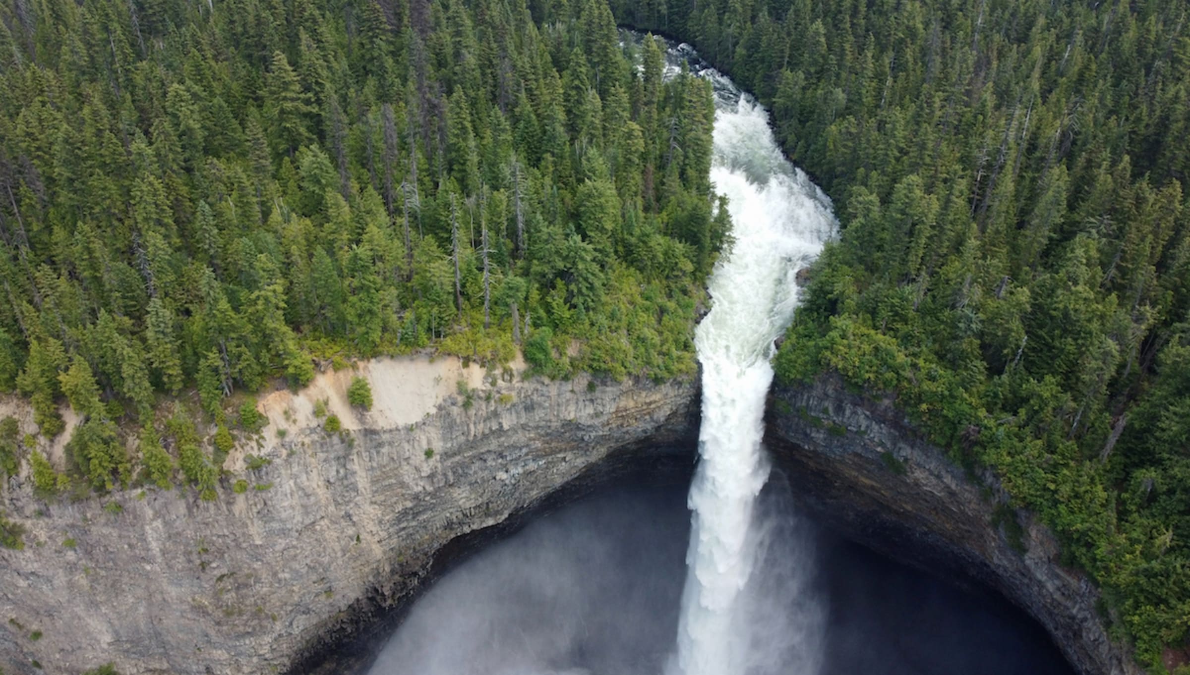
Photo by Matthew Manuel
In central British Columbia is a place nicknamed “Canada’s Waterfall Park”—if you’re looking for waterfalls, Wells Gray Provincial Park is the place to see ‘em. Imagine 1.3 million acres of temperate interior rainforest, an alpine wilderness born of volcanoes and carved by glaciers, with three Canadian river systems, skyscraping backcountry peaks, and more than 1,000 wildlife species. The area may not be as popular as the Rockies’ national parks, but its unique North America geography has shaped Wells Gray’s most prominent features: its 41 named waterfalls.
Late April through early July is the best time to see the popular waterfalls raging and at their most easily accessible, while January and February tend to freeze the falls in time and space with slippery access hiking trails. To help you plan your road trip through the park, we’ve selected 10 of the very best Wells Gray waterfalls to choose from—the ones you won’t want to miss, the ones off the beaten path, and the ones for every travel style whether you’re coming in from Prince George, Vancouver, Kamloops, or farther afield.
On the Murtle River

Dawson Falls
Best for families and leisurely hikers
- Distance from the Wells Gray Park Visitor Information Centre and main Clearwater entrance: About 35 minutes by road
- Hiking route to the falls: 1.1 kilometres (0.7 miles)
Seven of the park’s spectacular waterfalls are along the Murtle River, one of the Cariboo Mountains’ old lava beds, and Dawson Falls is one of them. Here, the river is shallow and broad, meaning the falls cascade and tumble 90 metres (300 feet) across and over a ledge. Known as “Little Niagara Falls,” Dawson roars, but simply take a few steps into the ancient cedars and hemlocks nearby and you’ll find that the thick temperate interior rainforest soaks all traces of sound.

The Mushbowl
Best for those who want easy-to-access classic views
- Distance from the Visitor Information Centre and main Clearwater entrance: About a 35-minute drive by road
- Hiking route to the falls: N/A, can be reached via the road
In an area known for whitewater rafting, the Mushbowl sits in a narrow canyon just downstream from Dawson Falls and not too far from Helmcken Falls. The exposed layers of rock found separating the two 4.5-meter (15-foot) Mushbowl cascades are the oldest rocks in the entire park. You can spot the fall from the one-way Clearwater Valley Road Bridge on your way to Helmcken.

Helmcken Falls
Best for wheelchair users and those short on time
- Distance from the Information Centre and main Clearwater entrance: About 40 minutes by road
- Hiking route to the falls: N/A, can be reached via the road
Helmcken Falls is not only the most famous waterfall in Wells Gray, but it’s also Canada’s fourth-highest waterfall and one of the driving reasons the provincial park was established. Just steps from Clearwater Valley Road and the parking lot, the waterfall provides the park’s most classic view. Visit the viewing platform, hanging over the canyon’s lip and overlooking the Murtle River, to see where the falls free-flow 141 meters (460 feet) to the canyon below. There’s also a one-hour hike along the Helmcken Falls Rim Trail, offering a bird’s-eye view of the falls. Catch Helmcken Falls in winter when temperatures dip below freezing to see its signature frozen cone rising 50 metres (165 feet) up out of the canyon.
On the main corridor near the entrance

Spahats Creek Falls
Best for those who want a low-key stroll
- Distance from the Wells Gray Park Visitor Information Centre and main Clearwater entrance: About 10 minutes by road
- Hiking route to the falls: 0.5 kilometres (0.3 miles) one-way
Easily reached in about a 5-minute walk from the parking lot, the 75-meter-high (245-foot) Spahats Falls are popular for their accessibility and the canyon rim views from its wooden platform. The tall, narrow waterfall cascades down into a wide gorge, making for an epic scene.
Triple Decker
Best for climbers and photographers
- Distance from the Information Centre and main Clearwater entrance: About 5 minutes by road
- Hiking route to the falls: 0.8 kilometres (0.5 miles) one-way
A short, sweet, and pretty steep journey in, this 60-meter-tall (200-foot), three-tiered waterfall sits along Candle Creek below Clearwater Valley Road. The dog-friendly Triple Decker also marks the start of a 7-kilometer (4.3-mile), one-way hike along the Clearwater River Trail.

Silvertip Falls
Best for those looking for a hidden gem
- Distance from the Information Centre and main Clearwater entrance: About 20 minutes by road (some gravel)
- Hiking route to the falls: 1.1 kilometres (0.7 miles) one-way
This waterfall spills about 200 meters (650 feet) over a cliff, but it’s more of a cascade than a free fall. Even still, Silvertip Falls is one of the tallest waterfalls in the park. Its Silvertip Falls Recreation Site location at the foot of Trophy Mountain means it gets a lot less foot traffic than other more popular spots in the park—just be sure to watch your step on the moderate incline.

McDiarmid Falls
Best for adventurers escaping the crowds for a challenge
- Distance from the Information Centre and main Clearwater entrance: About 35 minutes by road
- Hiking route to the falls: 3.1 kilometres (1.9 miles) one-way
Most visitors hike about 3 kilometres (1.8 miles) to reach Moul Falls, an impressive sight where you can trek down behind the veil and feel the mist of the falls. But continue on 100 meters (300 feet) downstream past Moul, along Grouse Creek, and you’ll find McDiarmid Falls. Very few people visit this 10-meter-high (32-foot) waterfall.
Near Canim Lake

Canim Falls and Mahood Falls
Best for walkers and those with limited mobility
- Distance from the Information Centre and main Clearwater entrance: About 90 minutes by road
- Hiking route to the falls: 1.1 kilometres (0.7 miles) one-way
A large parking lot sits about 6 kilometres (3.7 miles) from Mahood Lake Campground, and it’s here that you’ll find a trailhead for Canim Falls and Mahood Falls, twin waterfalls falling side by side and making for an incredible scene. After heading about 500 meters (0.3 miles) down a wide trail, you’ll spot Mahood Falls—and just another 500 meters (0.3 miles) along it is Canim Falls. A fenced-in observation area overlooks the pair. This spot is good for visitors arriving via the main Clearwater entrance or the western 100 Mile House side.
Deception Falls
Best for a challenge beyond Canim Falls
- Distance from the Information Centre and main Clearwater entrance: About 90 minutes by road
- Hiking route to the falls: 0.8 kilometres (0.5 miles) one-way
The Deception Falls trailhead can be reached via a rough park road not far from the Mahood Lake Campground. The hike is rather easy, but the best views of the tall falls are seen from very steep slopes overlooking the ravine. This spot is near Canim Falls and Mahood Falls, and is a good option for those entering the park via the western 100 Mile House side.
To the north

Bailey’s Chute
Best for those deep in the park
- Distance from the Visitor Information Centre and main Clearwater entrance: About an hour by road (just watch the rocky route!)
- Hiking route to the falls: 0.6 kilometres (0.4 miles) one-way
Up toward Clearwater Lake, this cascade is reached via a short walk that results in a scenic reward: crashing falls and rapids down below. Visit in late summer and fall for a look at the salmon jumping up the falls. If you’d like to keep going upon arrival, the West Lake Loop trail continues moderately past Bailey’s Chute to Marcus Falls, Myanth Falls, and West Lake. The whole hike is about 6.5 kilometres (4 miles) and takes about 2 hours.
Recent Posts
The Best Places to See Blooming Bluebells in the UK
As springtime hits the UK, the winter blues are replaced with a violet hue of a different kind. A carpet…
Morel Mushroom Hunting Season: The 2024 Camping Guide
Spring is springing. And we all know what that means—the 2024 morel mushroom season is underway. To increase your chances…
Hipcamp Awards 2024: Best RV & Van Spots in the US
To help you find the best camping in the country, each year we compile data from bookings, reviews, and ratings…
Hipcamp Awards 2024: Best RV & Van Spots in Canada
To help you find the best camping in the country, each year we compile data from bookings, reviews, and ratings…
Hipcamp Awards 2024: Best Caravan Spots in Australia
Awards season has arrived! To help you find the best camping in the country, each year we compile data from…
Hipcamp Awards 2024: Best Campervan Spots in the UK
To help you find the best camping in the country, each year we compile data from bookings, reviews, and ratings…